Geographic Information System (GIS): powerful and secure mapping data solutions
As pioneers in Geographic Information Systems since the 1990s, we design, develop and maintain mapping solutions to support decision-making for businesses, local authorities and public institutions.
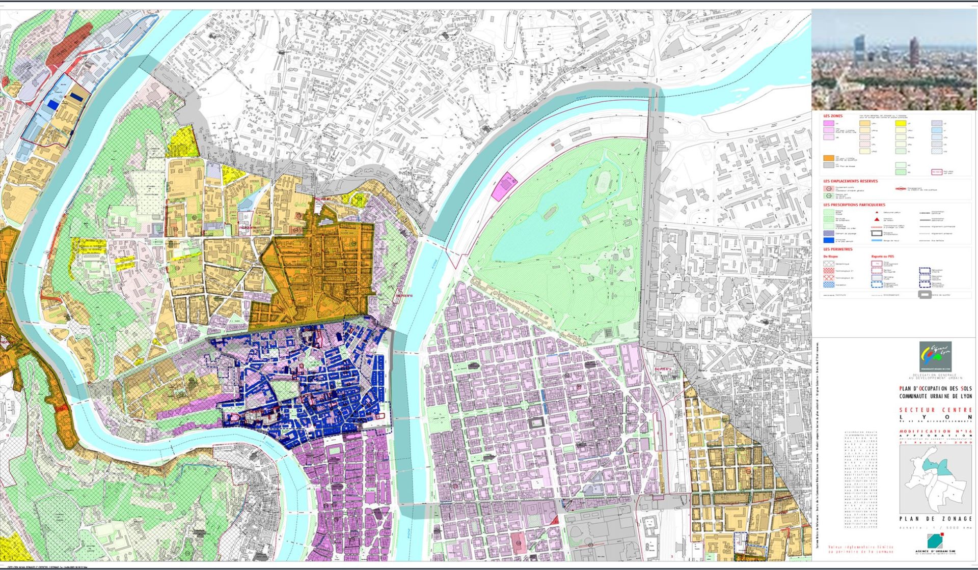
With over 100 specialists and 300 projects under our belt in the fields of energy, transport, healthcare, spatial planning and defence, we support organisations such as Greater Lyon, Paris La Défense, SNCF Réseau and Cerema. Our solutions are based on leading technologies: Esri ArcGIS, QGIS and PostGIS.
Why are GIS platforms and Geographic Data Infrastructures (GDI) tools for decision making?
Geographic information system technologies aim to collect, store, analyse and represent environmental data in the form of plans or maps. They are optimisation tools that have become indispensable in the decision-making process.
They are aimed at different targets (general public or professional experts) and cover many fields of intervention (environment, territory, networks, demography, tourism, health, etc.).

GIS application, a technology that has become indispensable in many fields
GIS platforms, like geographic data infrastructures (GDI), are designed to standardize the content and access processes of an organization’s geographic data.
Coexya’s range of services allows you to turn your ideas into production GIS solutions and to add value to your data to facilitate your decision-making:
- Functional and technical advice to our customers’ GIS teams,
- Implementation of GIS platforms and spatial data infrastructures (SDI),
- Development of collaborative and interoperable solutions, interfaces and web services,
- GIS interfacing with third-party information systems,
- Third-party application maintenance and third-party operations maintenance.
Coexya supports you in all your corporate mapping projects
Coexya offers a global and proven expertise in the field of GIS.
We have also developed a cutting-edge expertise in the integration and use of data in mobile situations, including indoor and real time / IoT.
Our missions: functional and technical support in the GIS domain, Lab, hackaton, PoC, crowdsourcing, design-to-cloud architecture.
Our method is based on 3 axes :
- To interactively bring out the needs of the organisation,
- Define the associated concrete processes,
- Reduce the time to market, time to value.
Development of business mapping solutions
Coexya delivers applications used for :
- The management of a territory : land registry, organisation of the public domain, coordination of works, agriculture and environmental management,
- The management of a water, gas, electricity or telecommunications network,
- The implementation of mobility services – MaaS,
- Management of land, property and furniture assets using BIM, CAD, 3D and IoT.
Coexya develops geocentric solutions, web services, geoprocessing and collaborative and interoperable cartographic components.
Coexya’s GIS Service Center has all the skills to assist you in your GIS interfacing projects with your third party systems.
Our GIS service centre also provides a series of connectors allowing the integration of the geographic dimension within :
- Third-party applications such as CMMS, ECM and PLM,
- High-performance and secure web and mobile solutions.
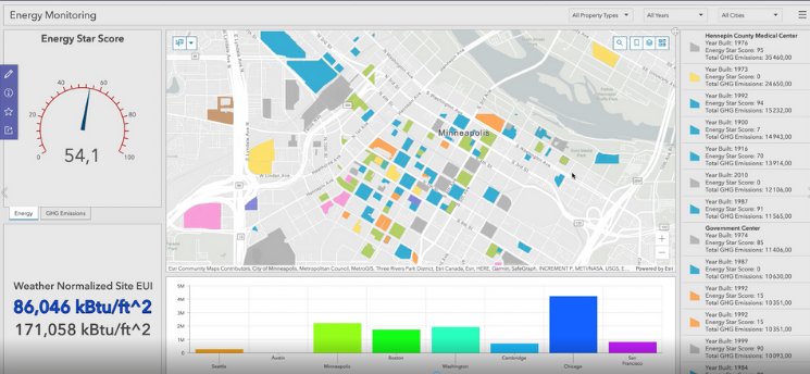
The combination of big data and GIS makes GeoAnalytics possible
GIS can better support decision making. For many years, Coexya has associated the geographical dimension with business intelligence software such as Power BI or Tableau Software. We intervene in the process of collecting, storing and analysing data from business operations in order to provide exhaustive indicators in real time.
In conjunction with Coexya’s teams dedicated to Big Data and Artificial Intelligence, we now offer our customers the implementation of GIS data pipelines based on tools such as Ni Fi and portals combining the power of semantic search engines and mapping components.
This approach encompasses activities such as data mining, statistical analysis and predictive modelling.
Innovations: Smart territories and Industry 4.0
The growth of our business coincides with the development of new value propositions in the field of intelligent cities and territories, mobility and industry 4.0.
Our engineers are innovating in this direction, coupling the geographical dimension with data and technologies in real time, 3D, augmented reality, artificial intelligence, cloud, BIM, CMMS and analytics.

Coexya, pioneer in the deployment of GIS infrastructure
A pioneer in the integration of the geographic dimension in information systems since the 90’s, Coexya is today recognized for its expertise in the design, implementation and maintenance of collaborative mapping solutions that bring concrete added value to your organization.
Our team is made up of over 100 passionate specialists who share a culture of innovation and commitment to results. We share with our clients, our technological partners and the research community more than 300 feedbacks in the fields of energy, transport, health, insurance, land use planning, industry and defence.
This multidisciplinary team combines consultants, geomaticians and IT architects. As a result, our GIS consulting method is recognised for its agile and participative approach.
Our Partners
ENSG
The ENSG is the French reference school for geomatics. It has achieved its reputation through the initial and professional training it offers, the partnerships it has developed and the expertise it demonstrates on a national and international level. It is part of the National Institute of Geographic and Forestry Information (IGN).
See moreOur references


Geo-Intelligence (GIS) Expertise: Why choose Coexya?
- Geospatial Data Engineering: Comprehensive expertise in the collection, structuring and modelling of complex spatial data to ensure the quality and accuracy of your geospatial datasets.
- Expertise in Leading & Open Source Solutions: Expert integration of market-leading technologies (Esri ArcGIS, Geocortex, QGIS, PostGIS) and development of bespoke solutions (WebGIS) tailored to your business processes.
- Interoperability & Standards (OGC): Implementation of data flows compliant with international standards (WMS, WFS, WMTS) and European directives (INSPIRE) to ensure seamless sharing between your platforms.
FAQ: Maximising Territorial Management with Powerful GIS
-
/ Why move from a desktop GIS to a WebGIS?
The core problem is information siloing. A desktop GIS restricts access to specialists, creating bottlenecks. WebGIS democratises access to geographic data: your teams can consult and update maps directly from a browser. A pioneer in GIS since the 1990s, Coexya supports this Desktop-to-WebGIS migration using market-leading technologies — Esri ArcGIS, Geocortex, QGIS — backed by a methodology proven across more than 300 projects.
-
/ How can you ensure data continuity between the office and the field?
Lack of synchronisation is a major source of errors for field operatives. A modern GIS solution incorporates offline mobile applications: technicians capture data on tablet and synchronisation happens automatically as soon as a connection is available. Coexya develops these field mobility solutions, including indoor and real-time / IoT modes, guaranteeing the integrity of your geographic database and eliminating duplicate administrative data entry.
-
/ Can my GIS connect to my ERP or CRM?
Interoperability is the key to a high-performing information system — a GIS should never be an isolated island. By connecting your GIS to your ERP or CMMS, you link your physical assets to their management data (invoicing, maintenance scheduling). Coexya’s GIS service centre provides proven connectors for integrating the geographic dimension within third-party applications (CMMS, ECM, PLM), ensuring interfacing with your existing systems in compliance with OGC standards (WMS, WFS, WMTS).
-
/ What are the options for modernising an outdated GIS at lower cost?
Technical obsolescence slows innovation, but modernisation does not necessarily mean a full replacement. Adopting Open Source solutions (QGIS, PostGIS, GeoServer) or integrating hybrid Cloud components can rationalise licence costs while increasing processing power. Coexya carries out an audit of your existing architecture to define a smooth, secure migration pathway, using an agile and participative methodology recognised by its clients.
-
/ How can I benefit from a local partner’s expertise across France (Paris, Lyon, Rennes, Lille, Brest, etc.)?
Geographical data is, by definition, local. Coexya deploys its GIS engineers and consultants from our offices in Paris, Lyon, Rennes, Lille, and Brest. This proximity allows us to understand the specificities of your regional data sets and to hold data modelling workshops directly at your premises, ensuring a perfect fit between the technical tool and your operational reality.